


 For all latest news, follow the Daily Sun's Google News channel.


Govt moves to prepare 30-year spatial plan
Tk463cr initiative to coordinate infrastructure, industry, housing and land use through 2056
Daily Sun Report, Dhaka
Published: 20 Sep 2026, 12:00 AM
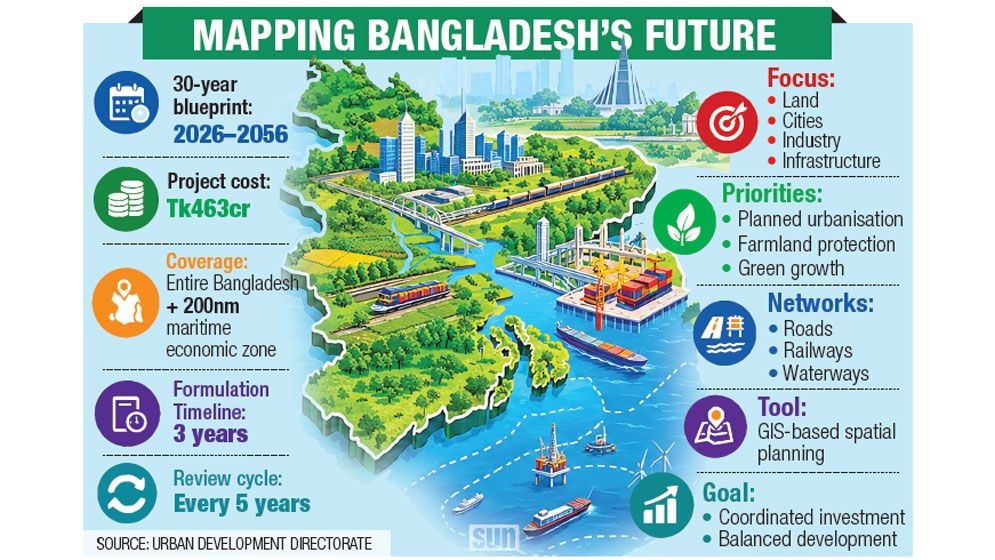
The government is moving to prepare a 30-year National Spatial Plan (NSP) to guide future investment in infrastructure, industry, housing and other development activities through more coordinated use of land and natural resources.
The Urban Development Directorate (UDD) has prepared a Tk463 crore project proposal to formulate the plan and recently sent it to the Planning Commission for approval. The government plans to complete the formulation process within three years.
Covering the entire territory of Bangladesh, including its landmass and the 200-nautical-mile exclusive economic zone, the NSP will span from 2026 to 2056.
According to UDD officials, the plan will establish an integrated, evidence-based framework for sustainable land and resource use while aligning cross-sector infrastructure projects and investment decisions.
A UDD planner said development activities in Bangladesh are often planned separately by different sectors without a national framework to coordinate them.
“In Bangladesh, roads are planned separately and railways separately. We’ve taken the initiative to formulate a National Spatial Plan to ensure coordination,” he said.
The proposed plan will identify suitable areas for industrial and residential development as well as potential routes for future rail and metro rail networks, he said.
“Our primary responsibility will be coordination and monitoring. Relevant sectoral agencies will implement the plans. For example, road projects will be implemented by the Roads and Highways Department or local government institutions,” he added.
The NSP will be reviewed and updated every five years to reflect changing socioeconomic, environmental and technological conditions, officials said.
The plan is intended to integrate planning at the national, regional and local levels, although its first phase will focus on national-level planning.
Why the plan matters
Bangladesh’s urban population increased from 23.3% in 2001 to 31.66% in 2021 and is projected to exceed 38.2% by 2035, according to the project proposal.
Urban areas generate more than 65% of the country’s GDP, increasing the need for integrated transport networks, planned industrial zones and better coordination of development activities.
The government also wants to ease pressure on Dhaka and promote decentralised development by classifying urban centres and encouraging planned, region-based migration.
The NSP will focus on planned urbanisation, sustainable industrialisation, protection of agricultural land, renewable energy development and integrated road, rail and waterway networks. GIS-based mapping will be used to guide land-use decisions.
Agricultural land has been declining by about 0.19% annually, according to the 2019 Agriculture Census.
The NSP will seek to protect farmland, identify areas suitable for different crops and promote climate-resilient agriculture. It will also set long-term development strategies, connect economic growth centres with regional corridors and establish integrated land-use guidelines and investment priorities.
The Spatial Planning Bill, 2026, was passed on 8 April, providing a legal framework for improving coordination between national and local planning and curbing unplanned development.
Adil Mohammed Khan, professor of urban and regional planning at Jahangirnagar University, said faster formulation and implementation of the NSP could help bring unplanned industrialisation and urbanisation under control.
He said the framework would make development activities more coordinated and effective.